

Garmin GPSMAP 66sr Handheld Outdoor GPS with U.S. & Canada Maps Birdseye Satellite Imagery GNSS Multi-Band Rugged Bundle w/Deco Gear Emergency Bracelet 2pk + Camping LED Lantern + Rechargeable AA Kit
$509.99


Price: $509.99
(as of Mar 21,2022 22:07:16 UTC – Details)

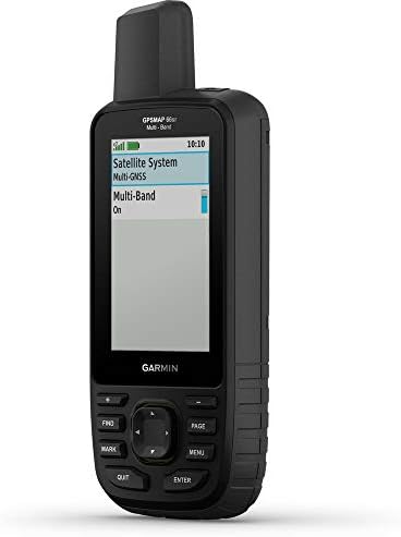
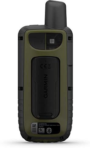
Find your way in this big, wide world with GPSMAP 66sr. This premium, rugged handheld offers multi-band technology and expanded GNSS support for optimal accuracy in steep country, urban canyons and forests with dense trees. It has a 3” color display, and it’s packed with ABC (altimeter, barometer and compass) sensors, routable TopoActive mapping and service package-free BirdsEye Satellite Imagery with unlimited direct-to-device access via Wi-Fi wireless networking. Wireless connectivity through BLUETOOTH and ANT+ technologies provides Active Weather and Geocaching Live updates, and compatibility with the Garmin Explore™ app (compatible smartphone required) gives you offline access to cloud-based route planning. EXPANDED GNSS SUPPORTMulti-band technology and expanded GNSS support (GPS, GLONASS, Galileo, QZSS and IRNSS) provide optimal accuracy in steep country, urban canyons and forests with dense trees.ABC SENSORSNavigate every trail with ABC sensors, including an altimeter for elevation data, barometer to monitor weather and 3-axis electronic compass.BIRDSEYE SATELLITE IMAGERYDownload high-resolution photo-realistic maps directly to your device without an annual service package. Easily find trails, pick stand locations, find parking, create waypoints and more.PRELOADED TOPO MAPSPreloaded TopoActive U.S. and Canada maps show you terrain contours, topographic elevations, summits, parks, coastlines, rivers, lakes and geographical points.PUBLIC LAND BOUNDA…
Garmin USA AUTHORIZED – Includes Full Garmin USA WARRANTY
Find your way in this big, wide world with GPSMAP« 66sr. This premium, rugged handheld offers Multi-band technology and expanded GNSS support (GPS, GLONASS, Galileo, QZSS and IRNSS) for optimal accuracy in steep country, urban canyons and dense forests. It has a 3″ color display, and it’s packed with ABC (altimeter, barometer and compass) sensors, routable TopoActive mapping and service package-free BirdsEye Satellite Imagery with unlimited direct-to-device access via Wi-Fi« wireless networking.
Navigate every trail with ABC sensors, including an altimeter for elevation data, barometer to monitor weather and 3-axis electronic compass. | Preloaded TopoActive U.S. and Canada maps show you terrain contours, topographic elevations, summits, parks, coastlines, rivers, lakes and geographical points. | Optional display of U.S. federal public land boundaries on topographical maps helps you know that you’re venturing where you’re supposed to be.
BIRDSEYE SATELLITE IMAGERY: Download high-resolution photo-realistic maps directly to your device without an annual service package. Easily find trails, pick stand locations, find parking, create waypoints and more. | Wireless connectivity through BLUETOOTH« and ANT+« technologies provides Active Weather and Geocaching Live updates, and compatibility with the Garmin Explore” app (compatible smartphone required) gives you offline access to cloud-based route planning.
BUNDLE INCLUDES: Garmin GPSMAP 66sr Handheld Outdoor GPS Navigator | TopoActive North America U.S. & Canada Maps | BirdsEye Satellite Imagery | USB Cable | Carabiner Clip | Deco Gear 2-Pack Tactical Emergency Essentials Paracord Bracelet with Compass SOS LED Light Whistle Camping Flint Multi Tool Functions | SanDisk 32GB Extreme Plus MicroSDHC Memory Card with Adapter | Wagan Tech Brite-Nite Dome LED Lantern 150 Lumens | GBX 4x Rechargeable AA Batteries w/ Charger
Related Products


$509.99