

Outdoor Trail Maps Collegiate Peaks Wilderness – Colorado Topographic Hiking Map (2018)
$8.95


Price: $8.95
(as of Mar 24,2022 09:31:08 UTC – Details)

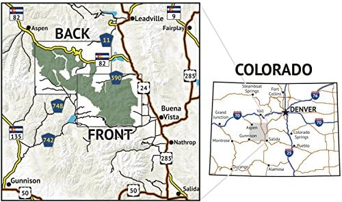
Waterproof, tear-resistant topographic hiking map covering all 135 miles of hiking trails in the Collegiate Peaks Wilderness area of Central Colorado and an additional 140 miles of trail in the surrounding areas. The map covers 8 Colorado 14ers inside the Collegiate Peaks Wilderness as well as a 9th: Mount Elbert. The front side of the map covers the eastern portion of the Wilderness, including Horn Fork Basin, Missouri Basin, the Three Apostles, Mount Yale and the Winfield area. The back of the map shows the western portion of the wilderness, including hiking areas around Mount Elbert, La Plata Basin, Independence Pass, New York Creek, Anderson and Petroleum Lakes, etc.
Waterproof, tear-resistant, 1:52,000 scale with a compact 4″x7″ folded size for your pocket
Smaller and lighter – no more unfurling huge maps – designed for on-trail use
Segment distances – mileage – for all trails
Updated for 2018 with accurate trail routings and distances
GPS coordinates for trailheads and trail junctions – device compatible
Related Products


$8.95