
Outdoor Trail Maps Colorado 14ers Series Front-Tenmile-Mosquito Range Map Pack
$21.95


Price: $21.95
(as of Mar 24,2022 17:49:02 UTC – Details)

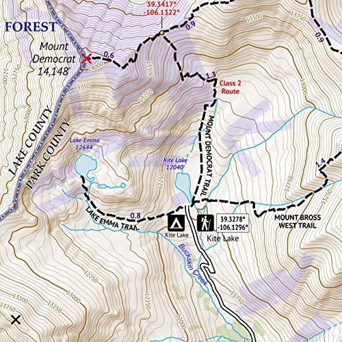
The Front-Tenmile-Mosquito Range Map Pack of the Colorado 14ers Map Series covers all of the Colorado 14ers found in the Front Range, Tenmile Range and Mosquito Range of Colorado across four maps (Map 1, Map 2, Map 3, and Map 4) – as well as Culebra Peak in the Sangre de Cristo Range. Peaks include: Mount Bierstadt, Mount Evans, Grays Peak, Torreys Peak (Map 1); Pikes Peak – East and West (Map 2); Longs Peak, Culebra Peak (Map 3); Mount Sherman, Mount Bross, Mount Cameron, Mount Democrat, Mount Lincoln and Quandary Peak (Map 4). This map pack saves you 12% off the retail price of these maps than if purchased separately. These rugged trail maps were designed for on-trail use in the toughest outdoor conditions in a compact and easy-to-fold size – no more fumbling with huge, inaccurate maps while on the go.
ALL the trails – not just the standard routes
Waterproof and tear-resistant paper, utralight weight – under an ounce
Detailed 1:30,000 scale (1 inch ≈ ½ mile), distances for all trail segments
Compact folded size to fit in your pocket – only 3.8” x 6.5” folded and 13″ x 19″ unfolded
GPS compatible: coordinates for all 14er trailheads – not just the popular ones – and for key trail junctions
Related Products